Digital Cartography
Primarily Carter County, Tennessee, and the Environs
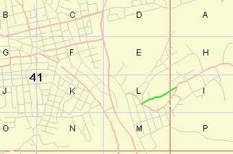
Carter County Tennessee Tax Assessor's Grid Map. Online software to locate and identify the combination of letter and number that identifies the lot of interest. Take the pair to the Carter County Tax Assessor's Office and the clerks will be able to show you a map of the area . This Java application is from ALOV. I've added my data to the engine. |
 |
||
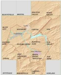 |
USGS Quads A Guide to the U.S.G.S. Quadrangles for Carter County, TN The U.S.G.S. divided the nation into seven and one-half degree quadrangles to make mapping the country easier to manage. Sixteen quads encompass all of Cater County. This guide will help you specify and locate maps in the federal government's mapping system. Topographic maps, Digital Elevation Maps, DOQ (Digital Ortho-rectified Quadrangle - aerial photograph) maps are freely available to the general public at some places on the internet. If you need paper maps, you will have to pay if the map is available. Some will not be. The file is an Acrobat PDF document. Most computers have the reader available. This is an online version |
||
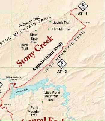
Logos as Font Characters A useful skill is construction of a logo as a font/typeface character (from images). An example is the Appalachian Trail sign used on the the trail. Another is the Overmountain Victory Historical Trail logo. Use of such logos on maps speeds up recognition and the search for landmarks. |
 |
||
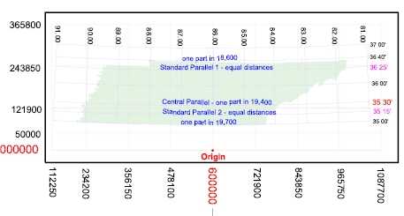 |
Tennessee State Plane Coordinate System |
||
|
 |
||
 |
|
| Deed
Search for a
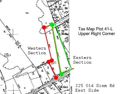
100 year old Afro-American Cemetery In 1915 a survey was conducted and the result erroneously omits corner points to the cemetery property, leaving half unidentified even though markers are present. Deed Search Notes |
|