
| DAYMET data - daymet.ornl.gov The Daymet Point data includes Year, DayofYear,
Day's Temp, Tmax, Tmin, SRAD, VPD, and Seconds in the
Day. The data is interpolated from samples and is the
result of the work of Peter E. Thornton, PhD. The data
can be downloaded from in any one of several forms and covers the period from 1980 to 1997. |
 Matlab plot of Daymet Temp data |
DAYMET data downloader software The program automates the download of a large number of points and uses latitude and longitude to bracket the area. Increments are set at tenths of a degree. The program will not work while Javascript is running. The only proven method is to make this the only program using web pages during the download, preferably overnight. No extensive testing has been done except for the opening set of parameters. No problem was encountered until a program using Javascript, simultaneously, was run. The downloader crashed. The program was written using Rapid-Q, a variant on the Basic language. The basis for the program was the duplication or manipulation of the server request made by the Daymet web page. As long as that code is viable, so is this program. Needless to say, no liability is presumed. Use at your own risk, etc., etc. |
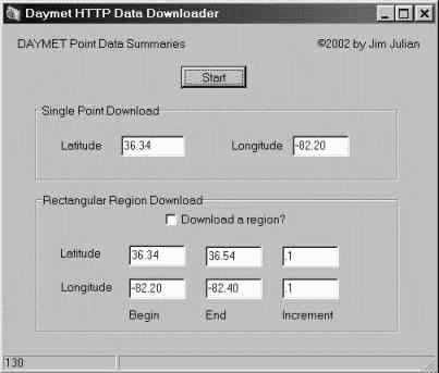 The Daymet Data Downloader |
CLIMB81 - Coop Precip - NCDC The CLIMB81 / Coop Precip data is from the NOAA-NCDC government site. The scripts for data extraction and manipulation are in the same package as the Daymet Matlab scripts. The data is in text format suitable for constructing a table and covers 1961-1990. There are Three temperature files, minimum, maximum, and mean(average) with data of four types: estimations, medians, normals, and standard deviations Download both *.dat and *.def files, the *.def files define the spacing in fixed space format. Also download the Station List. The stations are the first field in the data files. Coop Precip - the record of precipitation for the known historical record is included with reports dating back to 1900 with most beginning around 1948. The most current are 1997 reports. There is a reader script for Matlab, but not a plotter. The figure to the right is the Daymet data downloader. |
No Figure Available |